It’s common to apply a series of classifications to land in order to convey more specific information about it. Take, for example, political boundaries. You may work in St. Paul, which is a city in Ramsey County, within the state of Minnesota, which is part of the United States of America, and so on and so on.
Using the smallest subclassification makes it easier to specify where you work — it’s much more accurate to describe at the city level (St. Paul) than the country level (somewhere in the north-central United States).
Ecologists do the same thing when classifying land systems.
The Ecological Classification System (ECS) was developed to map and describe areas with similar characteristics, such as climate, geology, topography, soil, hydrology and vegetation. There are eight levels of ECS units in the United States, but for our purposes we will be exploring three: provinces, sections and subsections. Just like political boundaries, they start broadly and are divided into successively smaller units.
Provinces, sections and subsections
Minnesota has four provinces: The Eastern Broadleaf Forest, the Laurentian Mixed Forest, the Prairie Parkland and the Tallgrass Aspen Parklands. Those provinces are then divided into 10 sections, and further still into 26 subsections, each containing increasingly uniform ecological features as they are subdivided.
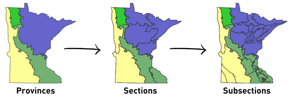
- Provinces are largely defined by their climate and native vegetation and are usually named by their geographic location and dominant vegetation type.
- Sections are defined further by their regional climate, surface geology and topography. Section names are often based on the topography or major geologic changes that shaped the area.
- Subsections are based on sub-regional climate, soils and potential vegetation. Names of subsections are usually derived from the primary geologic features of where they are located.
Finding your forest’s “address” in the Ecological Classification System
Just as using the city is more accurate than the country when describing where you work, knowing your land’s province, section and subsection will give you a much clearer picture of the possible management opportunities in your woodland.
Our advice to landowners is often tailored to one of these three levels. You will see lists sorted by ecological section in the series of recommended tree guides we’re rolling out this summer. And the Minnesota Department of Natural Resources has created an indispensable resource for woodland owners that is organized by groups of subsections, called the Woodlands of Minnesota Handbook series.
Even if you don’t own woods, we encourage you to explore the handbook series linked above. Select the area of the map that corresponds to your home or favorite slice of nature. You’ll learn so much about the natural history of the area, including the animals and plants that call it home, the geology and hydrology that shaped it, and how to start planning for your land’s future.