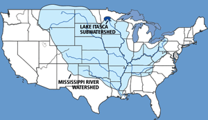
A watershed is all of the land and water areas that drain toward a particular lake or river segment. Thus, a watershed (or drainage basin) is defined in terms of each selected lake or river, such as "Mississippi river watershed".
Watersheds can be identified on different scales. Large scale watersheds are composed of smaller areas called subwatersheds. For example, the Mississippi river has an extremely large watershed, encompassing most of the central United States, including all or part of 31 states. In contrast, Lake Itasca in north central Minnesota has a relatively small watershed. As the source of the Mississippi river, Lake Itasca's drainage basin is considered a subwatershed of the entire Mississippi River basin.
The Minnesota Department of Natural Resources uses the following terminology to identify watersheds on different scales: regions, subregions, basins, subbasins, watersheds and subwatersheds.

Topography is the key element affecting how land drains to a particular point. The boundary of a watershed is defined by the highest elevations surrounding a lake or river segment. A drop of water falling outside of the boundary will drain to another watershed.
Reviewed in 2018