Quick facts
- Wetlands are identified by vegetation, soil and hydrology.
- There are many regulations that govern wetlands.
-
Many creatures depend on wetland fringes that border lakes and streams for nesting and food.
-
Wetlands provide flood control, reduce flood damage and improve water quality by filtering nutrients and pollutants.
-
Wetlands recharge and discharge ground water.
Why wetlands are important
Wetlands have many important roles, some very obvious, others less so. Many creatures, such as amphibians and migratory birds, depend on wetland fringes that border lakes and streams for nesting and food.
A not-so-obvious benefit of wetlands is flood control. Wetlands hold storm water and release it gradually, reducing flood damage and improving water quality by filtering nutrients and some pollutants. Wetlands also have aesthetic benefits and recharge and discharge ground water.
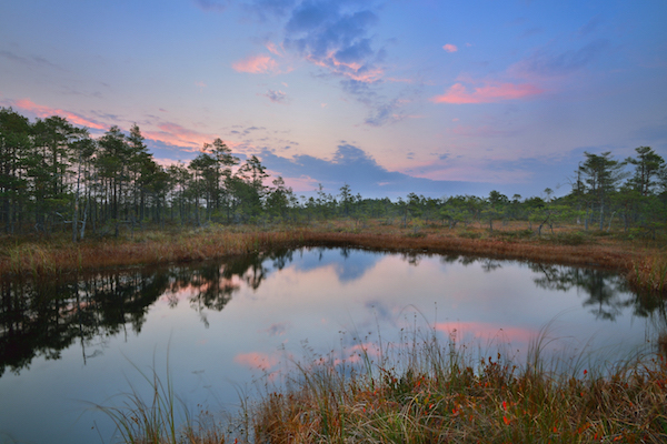
What is a wetland?
The term "wetland" is used to describe a wide variety of wet environments found in Minnesota. A wetland can range from a slight depression that holds water only after spring runoff to a forested swamp with saturated peat soils.
Most people probably would describe a wetland as a small body of open water with cattails on the fringe. Lakes and streams are generally not wetlands, but may be bordered by wetlands. How then do we know what is and what is not a wetland?
Wetland areas are identified on site using vegetation, soils and hydrology. The hardest part of defining a wetland is locating the boundary between the wetland and upland. This is called wetland delineation. When any of the above three criteria are no longer present, legally, you are out of a wetland and into the upland area.
How to identify wetlands
Since there are many laws today protecting wetlands, it's important to identify wetlands and define their boundaries. There are some clues that are helpful in determining wetland or non-wetland areas.
Water usually determines soil color and influences the vegetation found on a site. Therefore, vegetation, soils and hydrologic (water) factors must all be present in legal identification of a wetland. In undisturbed sites, vegetation is the most easily identifiable criterion and can be useful in wetland observations. Soils and hydrologic factors are more complex.
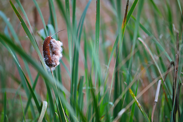
1. Vegetation
Wetland areas are usually dominated by vegetation that competes well or survives in wet conditions. In fact, some plants are almost always found in wetlands! These "obligate" wetland plants are good indicators of the existence of a wetland.
If you see the following obligate wetland plants, you are looking at a wetland:
- Bog rosemary
- Swamp milkweed
- Bog birch
- Sundew
- Cotton-grass
- Sand bar willow
- Black willow
- Skunk-cabbage
- Labrador tea
- Sphagnum moss
- Bulrush
- Wild rice
- Cattail
The following plants are usually found in wet areas and are fairly good indicators of the presence of a wetland. If any of these are found in the area of interest, investigate further to determine if it's a wetland:
- Red-osier dogwood
- Black spruce
- Larch (tamarack)
- Speckled alder
- Northern white cedar
- Black ash
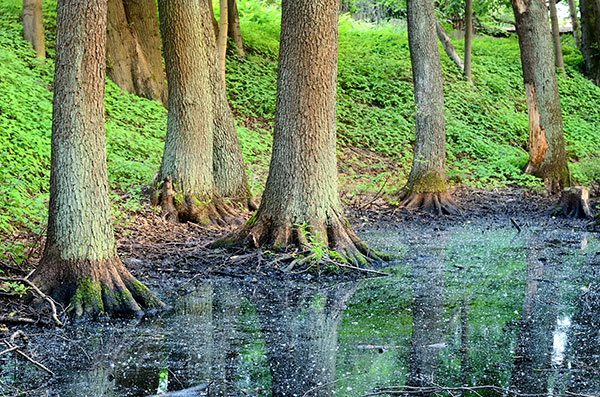
2. Soils
Soil development is also affected by water. In Minnesota, two major soil types develop in wet conditions. One is organic soils, or peat. The second is mineral soils that don't drain well because of low land, ground water seepage or a slowly permeable soil layer (e.g., clay, bedrock, or hardpan). These are both called hydric soils.
Organic soils or peat
Organic soils develop in depressions and consist of plant remains that do not decompose because soil is saturated. Organic soils can range in thickness from 2 to 30 feet. Plant parts are often still visible in many organic (peat) soils.
Mineral soils
Mineral soils that are saturated much of the time become dull-colored or gleyed. Gleyed soils are neutral gray and occasionally greenish or bluish gray.
Mineral soils saturated for short periods develop spots or blotches of different colors. These spots are called mottles and can be a sign of hydric or wetland soils.
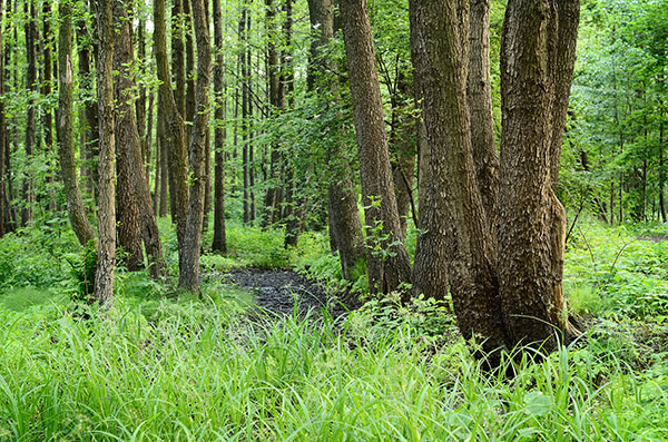
3. Hydrology
Hydrology is the third criterion used in describing a wetland. Hydrology refers to the presence or flow of water through the site. Some wetlands are relatively dry during drier times of the year (such as late summer). Often, aerial photographs, talking with neighbors and visual evidence are used to determine wetland hydrology.
Best management practices for wetlands
Avoid, minimize and replace are the watchwords for wetland protection.
- Avoid wetlands whenever possible.
- If you must disturb a wetland area, minimize disruption of the soil, vegetation and hydrology.
- A final alternative when a wetland is lost is mitigation by replacing it elsewhere.
Even very small wetland areas can help protect water quality. Following simple practices such as these on your property can help maintain the integrity and effectiveness of wetlands:
- Use docks or boardwalks to cross a wetland rather than filling.
- Lay out access paths along high ground, even if it means a longer walk to the shore.
- Preserve existing drainageways and never divert water to or from wetland areas.
Wetland replacement
If avoidance is not possible, replacement of an impacted wetland area or paying into a "wetland bank" are two alternatives. Both replacement and banking programs are coordinated with your local governmental unit (LGU).
Replacing an impacted wetland area with a wetland elsewhere on the landscape is ordinarily accomplished by:
- Restoring a wetland that was previously drained. Plugging an existing tile or building a dike is usually required to restore a wetland.
- Created wetlands are also generally acceptable for wetland replacement. Created wetlands can be achieved by shaping abandoned gravel pits or excavating upland areas.
Wetland banking
Wetland banking allows someone proposing a project to buy credits from a "bank" of wetlands that have been restored or created elsewhere. The bank of wetlands must first be established so that credit will be available for withdrawal. Payment for wetland bank credit acres will depend on many factors, including the cost of land in your area and the cost of creating or restoring wetlands.
Regulation of wetlands
Due to the loss of many wetlands, the Federal government and Minnesota have established regulations to protect remaining wetlands. Some local governments also regulate wetlands. Since wetlands themselves are so very complex, it follows that the laws protecting them are also complex.
The Minnesota Legislature passed the Wetland Conservation Act (WCA) in 1991. The goals of the WCA are to protect wetlands (no net loss) and make the process of wetland regulation more equitable. Responsibility for administering WCA lies with local governmental units (LGU) throughout Minnesota.
If you think you have a wetland, the best plan is to avoid impacting it. If you must consider a drain or fill activity near the wetland, follow these steps:
- Clearly outline the proposed project by drawing a sketch or writing a narrative.
- Contact your local zoning office or Soil and Water Conservation District (SWCD) for information on required permits.
- While at the zoning office or SWCD, request a Local-State-Federal Water Resource Project Notification Application Form. Complete this form by describing your proposed activity.
- Send copies of the form to all of these agencies:
- Municipal government or county.
- MN Department of Natural Resources (DNR) Division of Waters area office.
- U.S. Army Corps of Engineers (USACE)
- Soil and Water Conservation District (SWCD).
- Watershed District (if one exists in your area).
- These agencies should advise you of their jurisdiction or permit requirements within 45 days.
If it's determined by the regulators that you are impacting a wetland, you'll need permits. In Minnesota, permits are provided by these regulating agencies:
- U.S. Army Corp of Engineers - May regulate small wetlands regarding drainage or the placement of fill. If the Corps gives you an exemption from its regulations to place fill in a wetland, WCA may require replacement.
- MN Department of Natural Resources - Regulate wetlands listed on the Minnesota Protected Waters Inventory. A permit is required for any alteration.
- MN Pollution Control Agency (PCA) - May require permit for changes to wetlands that impact water quality. If a PCA permit is deemed necessary, your application will be automatically forwarded to them.
- Local government units (LGUs) may also have water quality ordinances regulating wetlands.
- All wetlands are covered by regulation through Wetland Conservation Act (WCA). LGUs (such as cities and counties) implement the WCA. Under WCA, if you impact a wetland, it may need to be replaced elsewhere unless it is granted an exemption.
If you can't avoid changing a wetland on your property, there will be some financial cost. There will be costs for getting permits to work in the wetland; there will also be mitigation costs for restoring wetlands:
- DNR permits for working on protected wetlands or streams depend on the size and scope of the project. Fees are charged.
- U.S. Army Corps of Engineers has permit fees for individuals and for commercial applications. These fees relate to nationwide permits. Larger projects may require individual permits with increased costs.
- LGUs may have fees in addition to building permits. Fees may be charged for inspecting erosion control near streams or for wetland replacement.
- The landowner may be responsible for delineating the wetland boundary by paying the LGU or by using a consultant.
- Costs for replacing a wetland vary greatly across Minnesota. Costs may range from $4,000 to $50,000 per acre to buy credits in the wetland bank. These costs depend on land acquisition, earthwork and seeding costs.
Let's say you want to build a new garage and driveway. If you think your property includes a wetland that may be affected by the project:
1. Your first step is to ask your LGU to check it out.
- If it determines that the area is in fact a wetland, you should consider altering your plans so the project doesn't impact the wetland.
- If there is no alternative, you will need to minimize impact and possibly provide wetland replacement.
2. After acquiring a building permit for the garage from your LGU, complete a project notification form describing the proposed project.
- The U.S. Army Corps of Engineers may determine that the fill area is small enough to be exempt from their program. However, WCA regulations will apply.
- If your driveway is 50 feet long by 15 feet wide, you will impact 750 square feet. The garage fill will require 20 feet by 18 feet or 360 square feet. Total wetland impact is 1,110 square feet.
3. Your LGU will review and approve or reject your proposed wetland replacement plan.
4. In this example, you would be required to replace the lost wetland.
- If replacement elsewhere on your property is impossible, there would be an assessed cost per square foot of filling.
- That money would be paid into a wetland bank and might range from a couple hundred dollars to $1,000 in this example.
Avoiding wetlands altogether is preferable, considering the potential costs of working near a wetland. But if you must impact a wetland, use practices to protect wetlands.
Reviewed in 2018