Groundwater is held in underground aquifers, geologic formations (sediment or rock layers) or groups of formations capable of yielding water to a well. An aquifer can be defined using a combination of geologic and practical features.
The geologic definition of an aquifer is a layer full of water and permeable geologic material. The practical description of an aquifer is that it can release significant quantities of water when pumped.
Contrary to popular belief, aquifers are not large underground lakes. Instead, they’re usually made up of large amounts of water flowing in between pore spaces and fractures. Think of a jar of marbles or cracks in underground rock filled with water.
Types of aquifers
What is an unconfined aquifer? (Video: 01:33)
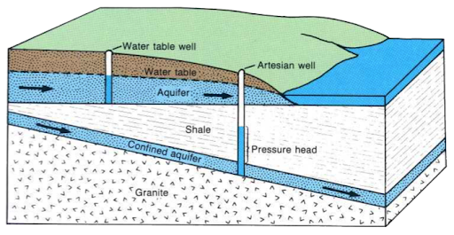
Unconfined aquifers receive water directly from the ground surface, usually as rain and snowmelt. The surface of the saturated zone is the water table, so sometimes these are called water table aquifers.
According to the USGS, “A water-table or unconfined aquifer is an aquifer whose upper water surface (water table) is at atmospheric pressure, and thus can rise and fall.”
Water-table aquifers are usually close to the Earth's surface, so they are commonly impacted by drought conditions and contaminants.
What is a confined aquifer? (Video: 02:14)
Aquifers that lie beneath a layer of clay or rock are considered confined. They are not as easily recharged by surface water. They may be under pressure, and if the confining layer is breached, the water will flow upward, even to the surface.
The USGS defines a confined aquifer as an aquifer below the land surface that is saturated with water. Layer(s) of impermeable material are both above and below the aquifer, causing it to be under pressure. When the aquifer is penetrated by a well, the water level in the well will rise above the top of the aquifer.
What is a cone of depression? (Video: 02:06)
A cone of depression is identified by a lowering of the water table surrounding a well because of pumping.
Any place where pumping from a well exceeds the rate of flow in an aquifer will form a cone of depression. This can affect other wells located close by.
Usually once pumping slows or stops, the aquifer will recover.
The makeup of aquifers in Minnesota
Three main kinds of geologic features hold water in aquifers in Minnesota.
Glacial sands and gravel aquifers
In Minnesota, where the state has been covered in ice at one time or another, sand and gravel deposited primarily by glacial meltwater streams is a common aquifer type. These may be at the surface or buried, of limited extent, or covering hundreds of square miles. They are mostly located in Central Minnesota.
Map of glacial sand and gravel representation in Minnesota.
Sedimentary rock aquifers
Long before Minnesota was covered in glaciers, much of southeastern and extreme northwestern areas of the state were covered by an ocean that deposited extensive and thick layers of sand, mud and lime to form sandstone, shale and limestone (or dolostone) aquifers. These are high-yielding aquifers and are regional in extent, covering and shared by much of the midcontinent.
Igneous and metamorphic rock aquifers
The bedrock underneath all of Minnesota was cooled from a molten state to form igneous rocks (like granite) or was under pressure and heat to form metamorphic rocks (like gneiss, schist or quartzite). These rock types generally do not have primary permeability (pores) but can have significant secondary permeability (fractures). The northeastern part of Minnesota has very little glacial sediment and therefore relies heavily on this type of aquifer.
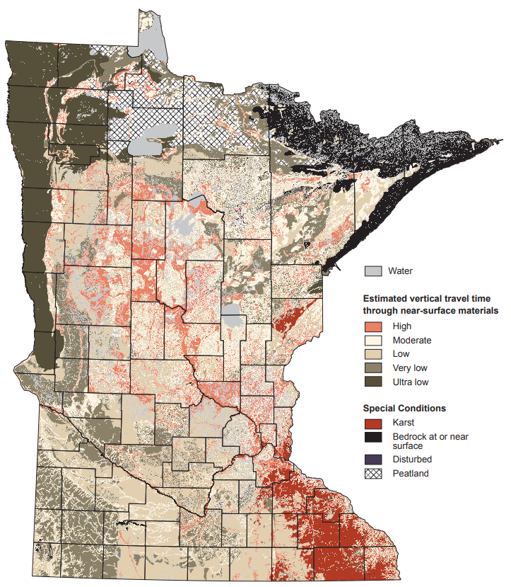
Groundwater contaminant susceptibility
Many factors can affect how quickly contaminants move from the soil at the surface to groundwater, including soil type, geological features, and depth to groundwater.
Coarse soils contain more sand and are more prevalent in central Minnesota, but can be found throughout the state.
Large spaces, known as pore space, fill with air and water between soil particles. This means water and any contaminants in the water move quickly through the soil profile and into the groundwater.
Map of coarse-textured soils based on the USDA NRCS soils map. Source: MDA

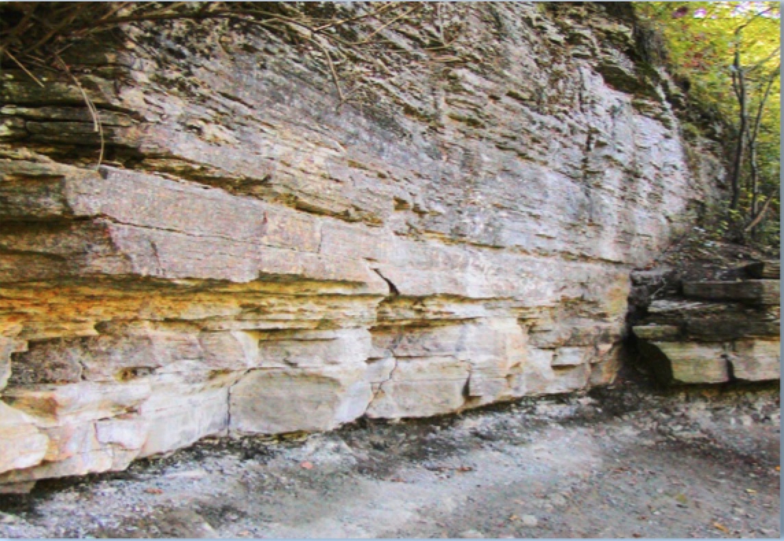
Karst geology is characterized by underlying limestone rock with systems of holes, channels, and tunnels, such as:
- Sinkholes
- Caves
- Bubbling springs
- Creeks that disappear underground
- Cracks in the rock
- “Stacked domino” appearance of rocks in road cuts
It creates small sucking holes that form in fields when soils are saturated with water.
These are more common in Southeast Minnesota and cause fast and direct movement of water and contaminants directly from the surface to groundwater.
- Quick movement of water from the surface and in the soil profile to groundwater because there is less soil between the surface and the groundwater.
- Short depth to groundwater.
- Less chance for water and contaminants to interact with the soil surface and soil organisms that can break down or incorporate contaminants.
- Map of shallow bedrock based on the USDA NRCS soils map. Source: MDA
Nitrates in groundwater and drinking water supply management areas (DWSMAs)
Nitrates are a form of nitrogen naturally occurring in soils. Plants use nitrogen as a source of energy. It helps give plants their green color and creates food for the plant through photosynthesis.
A common background level of nitrate in water is around 3 parts per million or lower. But several activities can increase the concentrations in water, one being the addition of nitrogen fertilizer to the soil. If concentrations are above 10 parts per million the water can have adverse effects on the health of infants.
DWSMAs are the protected areas surrounding a public well with elevated nitrate concentrations.
- A DWSMA is determined using the wellhead protection area extended to recognizable boundaries such as roads.
- The wellhead protection area is defined by the surface and subsurface area containing water that will reach the well within 10 years.
- DWSMA outlines are determined by the Minnesota Department of Health and can be found on the Minnesota Department of Agriculture (MDA) interactive map.
- DWSMAs are sorted into mitigation level designations determined by:
- Nitrate concentration level in the well.
- The trend on nitrate concentrations over time.
- Level of nitrogen fertilizer best management practice (BMP) adoption on farmland within the DWSMA.
- Map of the Cold Spring DWSMA.
More information on mitigation level designation can be found on the MDA groundwater protection rule web page. The DWSMA outlines and mitigation levels are updated every year on January 15.
Several factors can influence increased nitrate in public wells, including:
- Groundwater susceptibility (see above).
- Direct sources of nitrate to ground or surface water such as septic systems.
- Agricultural fertilizers.
The MDA and the University of Minnesota work with farmers in these areas to adopt best management practices that will help reduce nitrate concentrations entering the groundwater in these areas. Nitrogen management has a direct impact on crop yields as well as nitrate leaching to groundwater.
Reviewed in 2021