Whether you're landscaping your property, building a cabin or designing a large resort, you should have a landscape site plan. A site plan is a scaled drawing that shows the uses and structures proposed for a piece of land. It also includes information about the landscape features of your property.
While developing your plan, consider long-term objectives and how to reduce water runoff and optimize natural beauty. Check local regulations, get a survey and create a detailed map. Pay special attention to preventing erosion and minimizing damage during construction.
What's the purpose of a plan?
The site plan shows how your plans relate to the features of the land and surrounding area.
Protecting natural features and water quality
While developing this plan, special attention should be given to the natural features of your land and how you plan to protect them. By planning ahead, you can prevent problems that can be expensive or impossible to correct.
What could happen if I don't plan?
Making changes to the landscape without careful thought can create erosion problems. Plants and trees help to hold the soil and prevent erosion, especially on steep slopes. Removing them increases the chance for soil erosion. Soil erosion can lead to structural damage, reduced soil fertility and fill in road ditches.
Soil erosion harms rivers and lakes
Soil erosion harms your river or lake by causing excess sedimentation, killing aquatic bottom life and disrupting spawning. The sediment may lead to algal blooms, decreased lake depth and reduced aesthetic appeal. All of these potential problems are expensive to correct and, more importantly, can be avoided by proper water and land use practices.
Steps to developing your plan
1. Check local requirements and regulations
The first step is to check with your local planning and zoning office for information on shoreland requirements. These include setbacks, permits and building codes. Keep in mind, most ordinances restrict the total surface area that may be covered with impermeable materials (such as driveways, roofs and patios).
2. Get an existing conditions survey
If possible, hire a land surveyor to create an existing survey of your property. This survey should include:
- Property boundaries.
- Contour elevations (changes in elevation such as hills and sloping areas).
- Location of existing roads and driveways.
- Existing water wells.
- Scale (usually number of feet per inch).
- North directional arrow.
3. Create a detailed landscape map
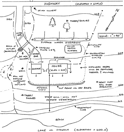
The survey can be used to create a detailed landscape map of the property (figure 1). On the map, these important features should be noted:
- Potential building sites.
- Potential sites of sewage treatment systems.
- Drainage patterns.
- Existing vegetation.
- Wildlife habitat.
- Land features such as wetlands and rock outcrops.
4. Plan the layout of the grounds
Think about the following goals when planning the layout. If you are working with a landscape architect, make sure these points are covered.
Long-term objectives
What are your long-term objectives for the property?
- How long do you plan on owning the property?
- What space do you require for your outdoor recreation activities?
- Do you want to create additional wildlife habitat?
- How compatible are your ideas with the expected long-term development objectives of the area?
- Do you plan on expanding or remodeling in the future?
- Does the "lay of the land" suit your ideas?
Site your septic and water well first
Site your septic system and water well in suitable areas before you finalize building locations and landscaping plans.
Reduce water runoff
- Driveways, walks and yard edges should follow level contours and gentle slopes.
- Do not lead water directly downhill. This gives it maximum speed and cutting power for erosion. Long, steep slopes have the greatest erosion potential.
- Consider putting small dams at intervals in ditches to slow runoff water and trap sediment.
- Cross-slope designs are better than up-and-down-hill ones.
Pay special attention to precautions to prevent soil erosion and water pollution.
Optimize natural beauty
Your site plan should optimize the natural beauty and attributes of your property. The site plan can be a 1 year, 10 year or a 25 year plan, depending on your resources and time.
4. Finished site plan
This finished plan uses the existing survey and incorporates the decisions made during step 4.
The finished site plan should include:
- Areas to be excavated and filling soil types (e.g., clay, sandy loam).
- Setback distances between shoreline and structures.
- Elevations of important features (such as buildings, drainage outlets or wetlands).
- Drainage patterns (streams or drainageways).
- Location of utilities (electric, gas, water or sewer).
- Areas needing protection to prevent erosion (such as unstable slopes and steep embankments).
- Vegetation (to be removed, added or left as is).
- Ordinary high water level of lake or river.
Preventing erosion and damage to existing landscapes during construction
Keep the site covered
Any disturbance of ground cover (grass or shrubs) will expose soil. This leads to erosion and slope failure.
- Use hay or straw as a mulch to cover disturbed areas after reseeding. A good rule of thumb is one 50-pound bale per 500 square feet.
- Consider working only in a small area and stabilizing that site before disturbing another.
Minimize disturbance to plants and trees
- Select and save trees to gain time in landscaping later.
- Protect trees from heavy equipment by encasing them with heavy planks tied vertically around the trunks.
- Large trees, especially birch, can be killed by heavy traffic that compacts the soil.
- Putting fill material too deeply over the root area can also kill trees.
Big, old dead trees, brush piles, and unmowed grass are "home" for a wide variety of wildlife. Save these whenever possible.
Maintain a filter strip
- Maintain a filter strip of natural vegetation along the banks of lakes and streams.
- The best filter strip is mature woodland with undisturbed grass and shrub layers.
Establish permanent cover
After your grounds have been graded to minimize and control runoff, the next step is to plant a permanent cover on all areas that have been disturbed.
Plant trees and shrubs
Trees and shrubs are excellent at protecting soil from rain and are practical erosion-control measures.
- Use native types of trees and shrubs wherever possible. They are well adapted to our climate, insects and diseases. Native trees and shrubs also create a landscape that needs minimal maintenance and is more natural.
- Trees and shrubs help buffer harsh winter winds and provide shade during hot summer days.
- Plants also serve as a living "fence" to provide privacy and excellent habitat for birds and other wildlife.
Use vegetation to help direct people away from sensitive areas, such as steep slopes.
Use pesticides and fertilizers carefully
Use only approved pesticides and follow label directions.
Plan streets and roads
Roads that follow general contours and moderate slopes offer less obstruction to natural drainage. They are also easier to stabilize and maintain.
- Plan driveway grades of 10% or less.
- Where steep slopes cannot be avoided, consider putting in "water bars." These small, raised ridges on the road surface help to route runoff water to road ditches, rather than allowing it to run the entire length of the slope.
- Properly sized culverts are also important for a well-drained road bed.
Control runoff
Rainfall and snow melt runoff should be directed to safe drainageways so that water will not scour and wash away soil.
- Curbs of dirt, timber or other materials can be placed at the crests of steep hills or cuts to divert runoff away from unprotected slopes.
- Diversions can also be constructed to control runoff. They collect runoff and lead it downhill to a safe outlet.
Don't forget that "hard" surfaces are impermeable to water and increase runoff. These impermeable surfaces include building roofs, roads, driveways, and patios.
- Minimize the amount of hard surfaces to help control excess runoff.
To prevent runoff damage by water:
- Keep it spread out, moving slowly.
- Divert it away from sensitive areas.
- Direct it to flow over erosion-resistant materials such as dense sod, rocks, plastic sheeting or concrete.
- Protect natural drainageways from filling with sediment.
For more information
For more information on local building conditions, contact contractors in the area. The local planning and zoning department can give you information on zoning regulations and wetlands.
- Soil and Water Conservation District (SWCD)
Conservation planning, soils, erosion control, wetlands - MN Department of Natural Resources (DNR)
Wildlife or fish habitat, shoreline erosion, permits
Reviewed in 2018